Quick Answer: Camarillo Airport (CMA) sits inside Class D airspace from 7 AM to 9 PM local time, so any drone flight inside that area during tower hours needs FAA authorization first. For most pilots the fastest route is LAANC: pick your spot in an FAA-approved LAANC app, stay at or below the grid altitude the FAA has set for that square (anywhere from 0 to 400 feet near CMA), and approval usually comes back in near real time. Above the grid, you need Further Coordination at least 72 hours ahead. Once you're cleared, the real job is staying alert: parachute jumpers, ultralights, helicopter training and military jets all show up in the FAA's notes for this airport.
I'm Tyler, an FAA Part 107 licensed remote pilot with Dragon Media. I've been flying commercially since 2019, and Camarillo, including Mission Oaks and Spanish Hills, is part of my regular service area. A lot of great Camarillo locations sit close to the airport, so here's the practical version of how I'd approach a flight there, without the legal deep dive.
This guide is for:
- Part 107 pilots picking up jobs in Camarillo, Spanish Hills or Mission Oaks
- Hobby flyers who live near the airport and want to fly by the book
- Real estate agents and property managers wondering if a listing near CMA can still get aerials
- Business owners near the airport planning aerial video
Where the Camarillo "no-fly zone" actually is
Most drone apps paint the area around Camarillo Airport red, which makes it look like a hard no-fly zone. It isn't. It's Class D controlled airspace, and you can fly in it with permission. Here's what the FAA's own data says about it.
| Camarillo Airport (CMA) | What the FAA lists | What it means when you fly |
|---|---|---|
| Airspace | Class D, from the surface up to 2,000 ft above sea level | Your whole flight (max 400 ft) is inside it, so you need authorization. |
| When it's active | Tower hours, 7 AM to 9 PM local. Other times it's Class G. | Most daytime shoots fall inside tower hours. Plan on getting authorization. |
| LAANC | Available at CMA | You can usually get approval from your phone in near real time. |
| Grid ceilings | 0, 100, 150, 200, 300 and 400 ft squares around the airport | Your square sets how high LAANC can approve. 0 ft squares near the runway need Further Coordination. |
| Neighbors | Oxnard Airport (Class D) about 6.5 miles west; Point Mugu restricted area R-2519 near the coast | Flying west or toward the coast means checking another set of rules. |
Planning tip: After 9 PM the tower closes and the airspace drops to Class G, so you don't need LAANC then. But the airport doesn't close. Planes still take off and land, nobody in a tower is watching, and night flying under Part 107 needs anti-collision lighting visible for 3 statute miles. If you can do the shot in daylight with an approval, that's usually the safer choice.
How to get permission to fly near Camarillo Airport
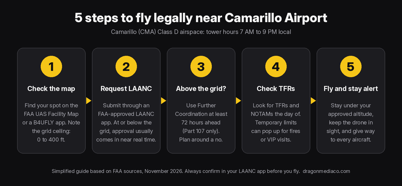
Getting cleared near CMA is mostly a five-minute job if you plan ahead. The order matters: check the map first, then request, then do your day-of checks.
| Your situation near CMA | What you need | How long it usually takes |
|---|---|---|
| Inside Class D during tower hours, at or below the grid altitude | LAANC authorization through an FAA-approved app (Part 107 or recreational) | Near real time. You can request up to 90 days ahead. |
| Inside Class D, above the grid altitude (including 0 ft squares) | Further Coordination through LAANC, reviewed by an Air Traffic Manager (Part 107 only, under 400 ft) | Submit at least 72 hours before you fly. It can be denied. |
| Outside the Class D boundary | No ATC authorization, but every other Part 107 or recreational rule still applies | None, just your normal preflight |
| A TFR is active (fire, VIP visit, event) | Stay out unless the TFR itself allows your flight | Check on the day. TFRs can pop up fast. |
Staying vigilant: what actually flies around Camarillo Airport
An approval only means air traffic control knows you'll be there. It doesn't move anyone out of your way. Under Part 107 your drone must give way to every aircraft, and it can't pass over, under or ahead of one unless it's well clear. The FAA's Chart Supplement entry for Camarillo calls out some traffic worth knowing about before you launch.
Camarillo Airport watch list
- Parachute jumping is listed at the airport. Look up, not just around.
- Ultralight activity in the southwest quadrant of the airport. They're slow, low and easy to miss.
- Helicopter training pads sit north of the runway. Helicopters can be much lower than planes.
- High-performance military aircraft operate near the airport, with Naval Base Ventura County at Point Mugu nearby.
- Traffic pattern altitude is about 800 ft above the ground for single-engine planes and 1,000 ft for twins and jets, so pattern traffic can be only 400 ft above your highest legal altitude.
- The runway runs east to west (Runways 8 and 26). Arrivals and departures line up on that path.
Practical habits for flying near CMA
- Set a max altitude in your app at or below the altitude you were approved for, so a stray thumb can't take you higher.
- Keep the approval on your phone with the time window. LAANC approvals are for a specific area, altitude and time.
- Bring a visual observer when you're close to the runway line. One person watches the drone, one watches the sky.
- Listen as well as look. If you hear an engine or rotor you can't see, bring the drone down and wait.
- Check TFRs and NOTAMs the morning of. Wildfire TFRs can pop up with little warning.
- Don't launch from airport property. On-airport flights are a different process from a normal LAANC request.
Rather hand it off? Hire a pilot who flies here
If you need aerial photos or video near Camarillo Airport and don't want to deal with the airspace, that's what I do. I'm FAA Part 107 licensed, I've been flying commercially since 2019, and Dragon Media carries $1M aggregate general liability including drone operations, plus $1M professional/media liability. I handle the LAANC request, the day-of checks and the flight, and I shoot with a 6K video / 100MP photo drone.
Rates are simple: $150 for the first hour and $100 for each additional hour. A drone roof inspection is $150 and takes about 30 minutes.
I'm based in Thousand Oaks and fly across Ventura County. See my drone services in Thousand Oaks, my Camarillo drone services page, and Oxnard drone services if your site is closer to OXR. For the bigger picture on all four local airports, read Flying Drones Near Camarillo, Oxnard, Van Nuys & Burbank Airports and my 2026 Ventura County drone regulations guide.
The bottom line
Camarillo Airport isn't a wall, it's a checkpoint. Check the grid, get LAANC (or Further Coordination with 72 hours to spare), look for TFRs, then fly like every aircraft in the sky has priority, because it does.
Sources (checked November 2026): FAA Chart Supplement, Camarillo (CMA); FAA Part 107 airspace authorizations; FAA LAANC; FAA UAS Facility Maps; B4UFLY; FAA TFR list; 14 CFR Part 107 (107.29, 107.37, 107.41, 107.51). This is a practical guide, not legal advice.