Quick answer: Yes, a drone shoot near Camarillo, Oxnard, Van Nuys or Burbank airport is usually possible. It just has to be done by the book. All four airports sit in controlled airspace (Class D at Camarillo, Oxnard and Van Nuys; Class C at Burbank). Under FAA Part 107, a licensed pilot needs FAA authorization before flying there, usually through LAANC. How high the drone can go depends on the exact grid square on the FAA UAS Facility Map. Close to the runways, some squares are 0 ft.
I'm Tyler, an FAA Part 107 licensed remote pilot with Dragon Media. I fly real estate, business and roof inspection shoots across Ventura County, including Camarillo, Oxnard, Thousand Oaks, Westlake Village and Moorpark. Here's what airport airspace means for your shoot, in plain English.
The four airports at a glance
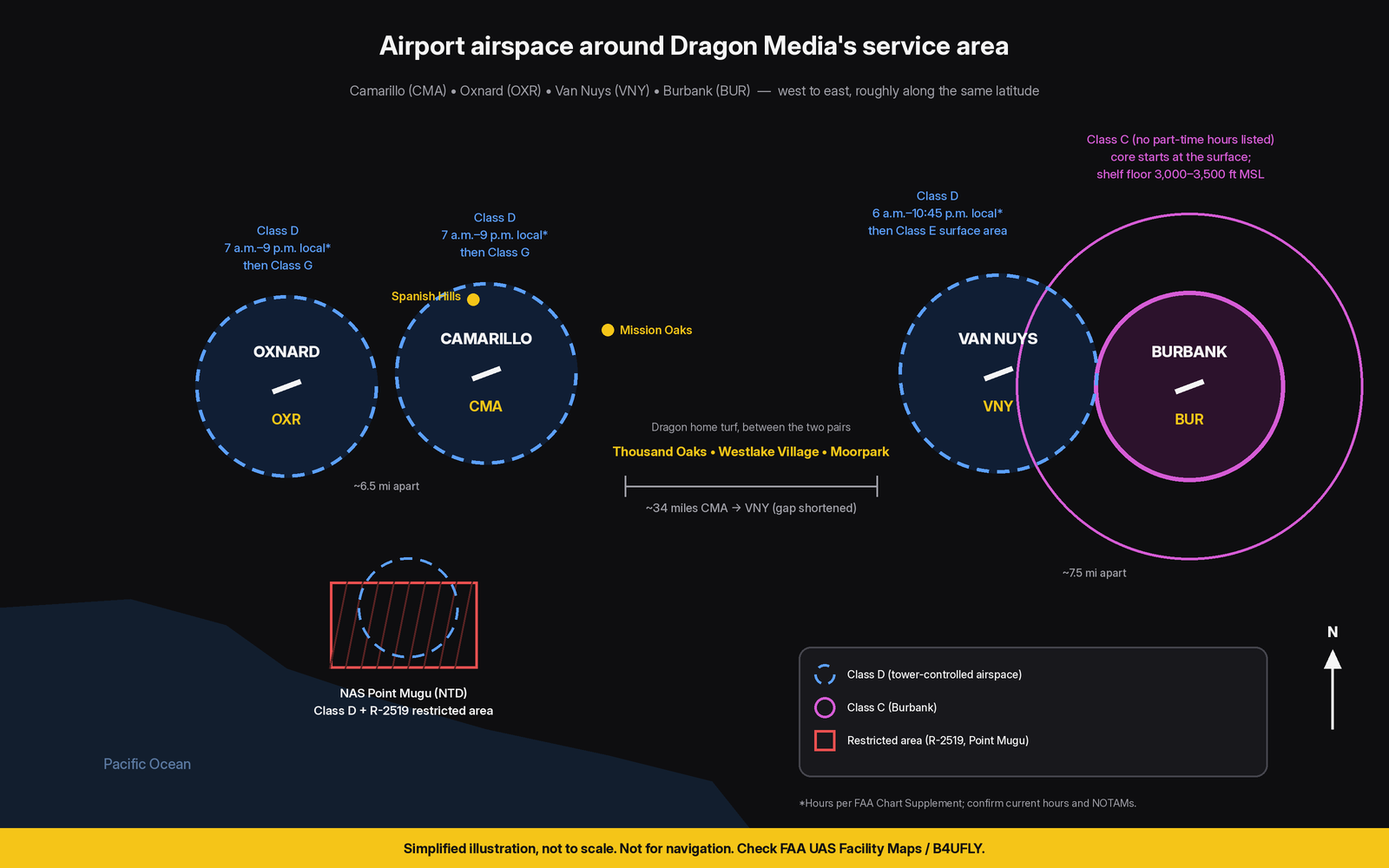
This table is based on the FAA Chart Supplement and the FAA's airspace and UAS Facility Map data, checked October 2026. Tower hours are shown in local time.
| Airport | ID | Airspace class | Who controls it | What it means for a drone shoot nearby | Nearby Dragon service areas |
|---|---|---|---|---|---|
| Camarillo Airport | CMA | Class D, surface to 2,000 ft MSL, 7 a.m. to 9 p.m. local. Class G when the tower is closed. | Camarillo Tower (part-time) | FAA authorization required while the Class D is active. LAANC is available; grid ceilings run from 0 to 400 ft. | Camarillo, including Spanish Hills (just north of the airport) and Mission Oaks (east side of town) |
| Oxnard Airport | OXR | Class D, surface to 2,000 ft MSL, 7 a.m. to 9 p.m. local. Class G when the tower is closed. | Oxnard Tower (part-time) | Same as Camarillo: authorization while the Class D is active. LAANC is available; grid ceilings run from 0 to 400 ft. NAS Point Mugu's airspace is close by to the southeast. | Oxnard, plus the west side of Camarillo |
| Van Nuys Airport | VNY | Class D, surface to 3,000 ft MSL, 6 a.m. to 10:45 p.m. local. Class E surface area at other times. | Van Nuys Tower; SoCal Approach | Authorization is needed around the clock, because the after-hours Class E surface area is still controlled airspace. LAANC is available; grid ceilings run from 0 to 400 ft. | Closest: Westlake Village and Thousand Oaks (to the west) |
| Hollywood Burbank Airport | BUR | Class C. The core starts at the surface (up to 4,800 ft MSL); the outer shelves start at 3,000 to 3,500 ft MSL. | Burbank Tower; SoCal Approach | Authorization is required inside the surface core. LAANC is available; grid ceilings run from 0 to 400 ft. The shelves start far above the 400 ft drone ceiling. | Outside Ventura County; closest are Westlake Village and Thousand Oaks (farther west) |
How airport airspace works (plain English)
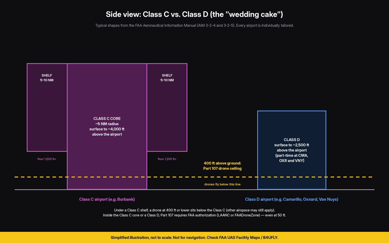
Think of the airspace around a towered airport as an upside-down wedding cake. Under Part 107, a drone generally has to stay at or below 400 ft above ground level (14 CFR 107.51). So what matters for a drone is the bottom layer of that cake.
Class D (Camarillo, Oxnard, Van Nuys)
Class D surrounds airports with an operating control tower. According to the FAA Aeronautical Information Manual (AIM 3-2-5), it generally runs from the surface to about 2,500 ft above the airport, though each one is tailored. Camarillo's and Oxnard's tops out at 2,000 ft MSL, and Van Nuys' at 3,000 ft MSL. Because it starts at the ground, a drone at 50 ft inside the ring is still in Class D.
Class C (Burbank)
Class C is for busier airports. AIM 3-2-4 describes the typical shape: a core about 5 nautical miles in radius that starts at the surface, plus a shelf out to about 10 nautical miles that starts higher up. Burbank's shelves begin at 3,000 to 3,500 ft MSL in the FAA's airspace data, far above where drones fly. The surface core is the part that matters for a drone shoot. Other airspace can still sit under the shelf, though, including Van Nuys' Class D.
The rule that ties it together
14 CFR 107.41 says no one may fly a small drone in Class B, C or D airspace, or within the surface area of Class E airspace designated for an airport, without prior authorization from Air Traffic Control. That authorization is what LAANC (or FAADroneZone) provides.
What happens when the tower closes?
The AIM explains that a part-time Class D can revert to either Class E or Class G after hours, and the Chart Supplement lists which one. As of this writing, Camarillo and Oxnard revert to Class G. Van Nuys reverts to a Class E surface area, which still requires authorization under 107.41. Flying after dark also brings its own rules, such as anti-collision lighting visible for 3 statute miles (14 CFR 107.29). Hours can change by NOTAM, so I check them on the day of the shoot.
Airport by airport: what I look at
Camarillo Airport (CMA): drone airspace in Camarillo
The FAA lists Camarillo Airport about 3 miles west of Camarillo. Its Class D covers a big part of the west side of town. Spanish Hills sits just north of the airport, and the FAA grids around it include 0 ft and 100 ft ceilings, so a Spanish Hills listing usually needs a careful plan and sometimes a further-coordination request. Mission Oaks, on the east side of town, is farther from the runway. Some of it sits outside the Class D grids, but ceilings change block by block, so I check every address. My Camarillo drone services page has more on local shoots.
Oxnard Airport (OXR): flying a drone near Oxnard Airport
Oxnard Airport is about 6.5 miles west of Camarillo Airport. It has the same Class D setup and the same tower hours. A little to the southeast is NAS Point Mugu, which has its own Class D. FAA data also shows restricted area R-2519 there, listed as continuous from the surface up, with offshore warning areas (W-289) that activate by NOTAM. A coastal shoot near Point Mugu gets an extra check from me.
Van Nuys Airport (VNY): drone flights in the west Valley
Van Nuys has a Class D up to 3,000 ft MSL while the tower is open (6 a.m. to 10:45 p.m. local). After hours it becomes a Class E surface area, so authorization is still required. If you're planning a sunrise or late-evening shoot in the west Valley, the airspace doesn't simply "turn off."
Hollywood Burbank Airport (BUR): drone near Burbank Airport
Burbank is Class C, and the FAA Chart Supplement lists no part-time hours. Near the airport, most grid squares are low or 0 ft. Farther out, under the shelves, the Class C doesn't start until thousands of feet up. Whatever airspace sits underneath, such as Van Nuys' Class D, still applies.
LAANC, grid ceilings and why "0 ft" happens
The FAA UAS Facility Maps divide the airspace into grid squares. Each square shows the maximum altitude the FAA may authorize without extra safety review. The maps don't authorize anything on their own; a pilot still has to request it. In the FAA data (effective October 1, 2026), all four airports have grid squares ranging from 0 ft near the runways up to 400 ft farther out. A 0 ft square doesn't automatically mean no, but it does mean the request goes to a human at the FAA:
| LAANC (at or below grid ceiling) | LAANC further coordination | FAADroneZone | |
|---|---|---|---|
| When it's used | Flight at or below the UAS Facility Map altitude | Flight above the grid altitude, up to 400 ft, including 0 ft grids (not on-airport operations). Part 107 pilots only. | Airports that aren't LAANC-enabled, or other requests processed manually |
| Who reviews it | Automated | An FAA Air Traffic Manager | FAA (manual review) |
| Timing | Typically near real time; can be requested up to 90 days ahead | Submit at least 72 hours before the flight, up to 90 days ahead | The FAA says processing has historically taken up to 8 weeks |
Source: FAA, Part 107 Airspace Authorizations and LAANC.
Before a drone shoot near an airport: my checklist
This is what I confirm before any flight near CMA, OXR, VNY or BUR. If you're hiring a pilot, it's also a good list of questions to ask.
- Find the airspace. Check the address on a sectional chart and a B4UFLY or LAANC app: Class C, Class D, Class E surface area or Class G?
- Read the grid ceiling. Look up the FAA UAS Facility Map square for the exact spot, which can be 0 to 400 ft.
- Check tower hours. Confirm when the Class D is active in the FAA Chart Supplement, and what it reverts to after hours.
- Request authorization. Use LAANC at or below the grid ceiling, or file further coordination (72+ hours ahead) or FAADroneZone if you need more.
- Check TFRs and NOTAMs. Look at tfr.faa.gov and the NOTAMs the day before and the morning of the flight.
- Check nearby special-use airspace. Near the coast, that means NAS Point Mugu (R-2519 and the W-289 warning areas).
- Confirm Remote ID. The drone must be Standard Remote ID or carry a broadcast module (FAA Remote ID).
- Check pilot credentials. The pilot needs a current Part 107 certificate (recurrent training every 24 calendar months).
- Get a certificate of insurance. Ask for a COI if your HOA, property manager or business requires one.
- Do a site check. Confirm 3-statute-mile visibility, cloud clearance, line of sight, people on site (operations over people rules), and lighting for twilight or night.
What this means for realtors, businesses and homeowners
Realtors: A listing near Camarillo or Oxnard Airport can usually still get aerials. Book a few days out if the property is in a low or 0 ft grid, in case a further-coordination request is needed. More on why aerials matter: the ROI of aerial real estate photography.
Homeowners: A $150 drone roof inspection takes about 30 minutes on site. Near an airport, the flight is low and short, but it still gets the same airspace check.
Businesses: If your building is in Spanish Hills, west Camarillo, or near Oxnard Airport, tell me the address when you reach out and I'll check the grid before we pick a date.
My rate for photo and video shoots is $150 for the first hour and $100 for each additional hour. I'm FAA Part 107 licensed and carry $600K aggregate GL + $1M professional/media liability. For a full price breakdown, see how much drone services cost in Ventura County. For a bigger picture of the rules, read drone regulations in 2026 and what to look for before hiring a drone company. You can also see all of my drone services in Ventura County.
FAQ
Can you legally fly a drone near Camarillo Airport?
Yes, with FAA authorization while the Class D is active (7 a.m. to 9 p.m. local, per the Chart Supplement) and at or below the approved altitude for that grid square. Squares closest to the runway can be 0 ft.
Can you fly a drone near Burbank Airport?
Inside Burbank's Class C surface core, only with ATC authorization. LAANC is available there, and many squares near the airport are low or 0 ft.
What is LAANC?
LAANC (Low Altitude Authorization and Notification Capability) is the FAA's system for authorizing drone flights under 400 ft in controlled airspace near airports. Requests go through FAA-approved service suppliers (apps), and the approved altitudes come from the UAS Facility Maps.
Does the airport need to know about my shoot?
The authorization comes from the FAA through LAANC or FAADroneZone, not from you calling the airport. That's the pilot's job, and it's part of why you hire a licensed one.
The bottom line
Being near Camarillo, Oxnard, Van Nuys or Burbank airport rarely rules out a drone shoot. It just means the flight needs the right authorization, the right altitude and a little lead time. Send me the address and the shots you want, and I'll tell you what the FAA map allows before we book.
Sources
FAA Chart Supplement (Southwest, Sep 3 – Oct 29, 2026): airspace class and tower hours for CMA, OXR, VNY and BUR
FAA Aeronautical Data Delivery Service: Class Airspace, Special Use Airspace and UAS Facility Map data
FAA Aeronautical Information Manual, Chapter 3, Section 2 (Class C and Class D)
14 CFR Part 107 (107.29, 107.41, 107.51, 107.65)
AirNav (secondary): local tower hours for CMA, OXR and VNY
Simplified for planning conversations, not for navigation. Airspace and hours change. Always check current FAA data before flying.